Suggested Itinerary
Day 1: Kathmandu-Bhadrapur ( Taplejung) by flight- Fungling ( 600m./1980ft.) 4 hrs. drive
We take a flight in the morning to Bhadrapur (Taplejung) then drive to Fungling and stay overnight there at hotel.
Meals included : Breakfast, Lunch, Dinner
Day 2: Fungling - Mitlung (909m./2999ft.) 5 hrs. walk
The first day trek starts from Fungling (1777m) – the headquarters of Taplejung district. Sherpa Tol is the gateway to this trek. The trek passes through beautiful cardamom fields and Alnus trees (Uttis) until Hangdewa VDC which takes around two and half hours. On the way, there are small tea shops at Asangpati Tole, Gaigode Tole and Panisar Tole that can be used for alternative accommodation as they provide home stay facilities. From Panisar, the trek is downhill until the suspension bridge that acts as a border between Hangdewa VDC and Furumbu VDC. A walk of 10 minutes takes us to Pawa Village (1546m) for lunch. After lunch, the trek progresses along the banks of Tamor River to Mitlung – a walk of around two hours. Mitlung (909m) is our destination for the day as it has good camping sites with facilities like kitchen and dining hall.
Meals included : Breakfast, Lunch, Dinner
Day 3: Mitlung -Chiruwa ( 1246m./4111ft.) 5 hrs. walk
The trek passes along the banks of Tamor River on the second day. It is a pleasing walk until Furumbu – a 40 minute walk from Mitlung. From Furumbu, the trail is uphill for half hour then descends through Ulnus and Schima wallachiana mixed forest to Siwa Bazar (950m) at Linkhim VDC. We can reach Siwa Bazaar in three hours from Mitlung. Siwa Bazar is a good place for lunch. It is a small market with facilities like drug store, groceries and a police station. After lunch, the trek runs along the Tamor River until Tawa Village. Tawa Village (1146m) has a small tea shop. The trek runs uphill from here until we reach the KCAP Entrance Gate (1300m) at Thiwa Village. From here, the trek gradually descends until Chiruwa – our destination for the day. Chiruwa is a small market with couple of lodges and good camping sites. It is a popular stopover for tourists and locals alike.
Meals included : Breakfast, Lunch, Dinner
Day 4: Chiruwa - Lelep ( 1687m./5567ft.) 5 hrs. walk
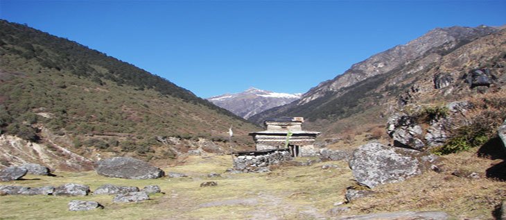
This day also the trek runs along the mighty Tamor River. At the start of the trek, there are two big stones with religious significance. The trek passes through Ulnus trees passes until we reach a big landslide that takes around half an hour to cross. After a walk of two and half hours from Chiruwa through beautiful cardamom gardens, we reach Tapethok (1340m) for lunch. It is a small market with some tea shops. There is also a KCAP checkpoint at Tapethok. After lunch, it is a pleasing walk for about an hour until Pembu (1486m). From Pembu, it is an uphill climb for about two and half hours to Lelep – our destination for the day. The KCAP headquarters is in Lelep. Similarly, there is a police station, some tea shops, groceries and hotels. There are also some good camping sites in Lelep.
Meals included : Breakfast, Lunch, Dinner
Day 5: Lelep - Ela Danda ( 2051m./6768ft.) 5 hrs. walk
After breakfast, the trek runs along the bank of Tamor River through dense forest that offers good habitat for different wildlife species. You can see some wild species if you are lucky. We crossed a suspension bridge after a walk of about an hour from Lelep. After crossing suspension bridge, it is an uphill climb through pine forest for about half an hour until we reach a monastery. From there, the trek gradually descends after about half an hour and we reach Gowatar (1800m) for lunch. Gowatar is a small settlement with a few houses. Near the village, there is a big stone and it is believed that only the religious people can move them. After a walk of around half hour from Gowatar, we reach a place that offers spectacular views of two waterfalls about 100 meters tall. A walk of about half an hour form here takes us to Phedi. After crossing Tamor River, it is an uphill climb for about 40 minutes until we reach a resting place known as chautaro in local dialect. Another 20 minutes walk will take us to our camping site at Ela Danda. The place offers panoramic view of snowcapped peaks including the Small Kasturi Peak and Tamor River.
Meals included : Breakfast, Lunch, Dinner
Day 6: Ela Danda- Selep Kharka ( 2525m./8332ft.) 6 hrs. walk
The walk on the fifth day is pleasing as it passes through Ulnus and Rhododendron forest for about an hour until we reach a suspension bridge. After crossing the suspension bridge, the trek passes through dense bamboo groves (spread over around 5 hectares). This place is popular among trekkers as the habitat of red panda. If you are lucky, we might catch a sight of red panda from the trail itself. After a total walk of three and half hours from El Danda, we reach Maguwa (2435m) for lunch. After lunch, the trail passes through maple and Ulnus forest. There is a big landslide on the way and trekkers must be careful while crossing it. After a walk of about one and half hour, we reach Selep Kharka – our destination for the day.
Meals included: Breakfast, Lunch, Dinner
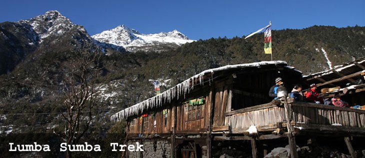
Day 7: Selep Kharka- Olangchung Gola ( 3208m./10586ft.) 5 hrs. walk
The sixth day’s trek runs along the banks of Tamor River leading to a place called Jongim (2641), a flat land surrounded by snow capped hills, after a walk of about an hour. Another 40 minutes walk through rhododendron forest from Jongim, takes us to a suspension bridge. After an uphill walk of about an hour from the suspension bridge, we reach Ramite (2685m) for lunch. At Ramite, we can see mixed forest of Deodar and rhododendron. We see a beautiful waterfall after a walk of about an hour from Ramite. If you are lucky, you might be rewarded with the view of red panda from here. We caught the first glimpse of Olangchung Gola after a walk of around 45 minutes from the waterfall. After a climb of about 40 minutes, we finally reach the camping site at Olangchung Gola (3208m). Olangchung Gola is a beautiful Sherpa village with around 45 houses, a 465 years old monastery with golden manuscript and KCAP office. There is also a sub-health post, a primary school and a border police station at Olangchung Gola.
Meals included : Breakfast, Lunch, Dinner
Day 8: Olangchung Gola-Upper Langmale ( 3893m./12846ft.) 5 hrs. walk
The trek in the next three days will pass through complete wilderness. As the trek is in complete wilderness, it is better to hire a local Sherpa to avoid getting lost. However, piles of stones along the way act as sign posts, showing us our direction. The trek passes through pine and rhododendron forests. After a walk of two and half hours, we reach a place called Jadak (3636m) for lunch. A walk of three hours on snowy track will take us to our camping site at Upper Langmale.
Meals included : Breakfast, Lunch, Dinner
Day 9: Upper Langmale - Pass Camp (4747m./15665ft.) 6 hrs. walk
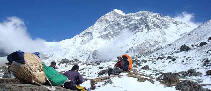
The eighth day trek can be interesting as snow leopards have been sighted numerous times from this trek. The trek runs along the Tamor River and on the other side of the river lies dense rhododendron forest. After a walk of about three hours, we reach Tangchetar (4203m) for lunch. Another three hours walk after lunch will lead us to our camping site at Pass Camp.
Meals included: Breakfast, Lunch, Dinner
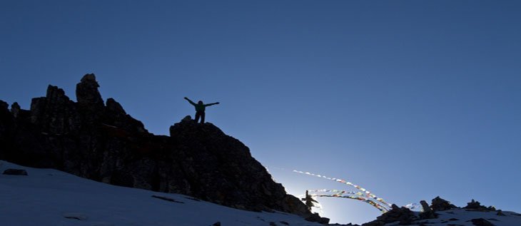
Day 10:Pass Camp - Chaurikharka ( 4594m./15160ft.) 4 hrs. walk
This would be the most difficult yet most memorable day of this trek. This day the trek will pass through the Lumba Sumba Peak (5200m). It is better to start early as it will be difficult to cross the peak after noon. The trek climbs a bit up and again runs down. It is better to take packed lunch, as there are no good camping sites around. After a walk of about four and half hour from Pass Camp, we climb the Lumba Sumba Peak and descend down to Chaurikharka for night’s stay.
Meals included : Breakfast, Lunch, Dinner
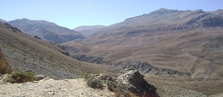
Day 11:Chaurikharka-Thaudam ( 3500m./11550ft.) 5 hrs. walk
The trek is downhill from Chaurikharka as we come back to civilization after tiring walk for three days. After a walk of about three and half hours, we came across two roads – one to Lyasha in Tibet and the other toward Thudam. We prepared our lunch at this place. A walk of about three hours takes us to Thudam for the night’s accommodation. Thudam is a small village with around 30 houses of Sherpa people.
Meals included: Breakfast, Lunch, Dinner
Day 12: Thudam - Kharka ( 2877m./9494ft.) 5 hrs. walk
The eleventh day trek runs along the banks of Chujung Khola. The trail offers panoramic view of peaks in the Makalu range. On the way you see lot of small bushes and bamboo groves – the best habitat for red panda. If you are lucky, you can see this endangered species. It is better to carry packed lunch, as it is difficult to find drinking water along the trail. After a walk of about six-hours from Thudam, we reach Kharka for the night’s halt.
Meals included : Breakfast, Lunch, Dinner
Day 13: Kharka - Chyamthang ( 2229m./7355ft.) 5 hrs. walk
The twelfth day’s walk passes through dense rhododendron forest. As there are no villages on the way and also there are numerous side trails, it is better to hire a local guide to avoid getting lost. After a walk of about three hours form Kharka, we reach a place called Chaurikharka for lunch. From Chaurikharka, we can clearly see Chyamtang (2229m), Arun River, Ridha Village and the road that leads to Kimathanka. After lunch, the trek is all downhill for about three hours until we reach Arun River. After crossing the suspension bridge over the Arun, the trek is uphill for about an hour until Chyamthang – our destination for the day. Chyamthang is a small yet beautiful village with stone houses. Sherpas are the dominant population in the village.
Meals included : Breakfast, Lunch, Dinner
Day 14: Chyamthang- Hatiya ( 1595m./5263ft.) 6 hrs. walk
The trail on the day passes through rhododendron forest. The walk is easy as chirping of birds make you feel refreshed. The trail is one of the popular places for birding as we are entering Arun Valley that is home to several bird species. A walk of about two and half hours from Chyamthang takes us to Gimber Village (1585m) for lunch. Gimber Village offers spectacular view of snowcapped peaks in the Makalu range. From Gimber, the walk is easy and after a trek of about three hours we reach Hatiya for the night’s stay. Hatiya – a small village of Bhote people – is the entry point to the Makalu National Park.
Meals included : Breakfast, Lunch, Dinner
Day 15: Hatiya - Gola (1128m./3722ft.) 5 hrs. walk
The trek on the 14th day runs along the banks of Arun River. After a walk of about two and half hours from Hatiya, we reach the confluence of Arun and Barun rivers. After having lunch near the river confluence, the trek progress toward Gola – our destination for the day. A walk of around two and half hours after lunch takes us to our camping site at Gola. Gola is a very small village with only 12 houses. Sherpa, Rai and Tamang people reside here.
Meals included : Breakfast, Lunch, Dinner
Day 16: Gola -Gadhi ( 1179m./3890ft.) 5 hrs. walk
The trek passes through paddy fields on the 15th day – a sign that we are at lowlands now. The walk is pleasing as the trail makes a short descent, but again makes a short climb. After a walk of about two and half hours from Gola, we reach Pathibhara (not to be confused with the Pathibhara temple in Taplejung district) for lunch. Pathibhara (1524m) is a small Gurung village with tea shops, groceries and some hotels. The trail after lunch passes through agricultural land and we can find plenty of water sources and small settlements along the way. We reach Gadhi (1179m) – our destination for the day – after a walk of around three hours from Pathibhara. Gadhi (that means fort in Nepali language) is a place of great historical significance as Nepali Army fought bravely with invading Tibetan Army at this place and chased them away. Gadhi is a small village market with a health post, a school and a police station.
Meals included : Breakfast, Lunch, Dinner
Day 17: Gadhi - Tumlingtar overland and Kathmandu by flight
This is the last day of our trek. Drive to Tumlingtar airstrip and fly directly to Kathmandu.
Meals included: Breakfast
Trek Ends


 Quick Inquiry